On that August day in 2019, the water beside Morača Monastery looked nothing like an elemental force. White walls stood among greenery and stone, the river followed its course below, and we were ordinary travellers who had come to see one of Montenegro’s oldest monasteries. At the time, everything seemed separate: history here, mountains a little farther on, then a canyon, a bridge, another stop for the bus.
Years later, while going through the photographs, I saw a different route. For almost the entire day we had travelled beside water: Morača, then a road squeezed between river and rock, Tara cutting through a deep canyon, the bridge above it, and finally Piva, where people no longer merely searched for a convenient passage through an existing landscape but altered the river itself and created a new shoreline.
It had become a story about water that first exists beside people, then enters their faith and thought, gradually yields its laws to science, and finally becomes part of engineering calculation. Yet the old idea of an elemental force has never quite left our language.
Water beside the walls of Morača
Morača Monastery has stood here since the thirteenth century. Its main Church of the Dormition was built in 1251–1252 at the will of Prince Stefan, son of Vukan and grandson of Stefan Nemanja. Soon after construction, the stone walls were covered with paintings. Little of that original decoration survives: much was lost, while the best-known fragments from the thirteenth century remain in the diaconicon, where a cycle devoted to the prophet Elijah unfolds [1].
One of its most famous scenes shows a raven bringing food to Elijah. In the biblical story, the prophet hides beside the brook Cherith during a drought and drinks from it until the stream dries up. The Kolašin Tourism Organisation describes The Raven Feeding the Prophet Elijah as the oldest and one of the best-known frescoes at Morača [2].
Freely licensed photographs of the Elijah cycle itself are hard to find. The two images below show later paintings in the Morača complex: seventeenth-century frescoes in the Chapel of Saint Nicholas and the sixteenth- to seventeenth-century Last Judgment on the church portal. They belong to a different period, but they make clear how completely painting is woven into the architecture here.
Photos: Wolfgang Sauber / Wikimedia Commons: Chapel of Saint Nicholas, Last Judgment. Licensed under CC BY-SA 4.0. Images were resized without cropping.


Outside the church, the real Morača flows past. Inside, the memory of another stream has endured for more than seven centuries. The proximity hardly needs explanation: water accompanied human life for too long to remain merely a substance. A spring sustained life; a river divided banks and at the same time connected settlements; the sea fed people and occasionally reminded them of its power; harvests depended on rain.
Christianity does not turn the river into a deity. Nature remains creation, but water retains a rich symbolic language. In Orthodox baptism, immersion is associated with leaving an old state behind and beginning a new life; material water is at once part of the rite and an image of passage [3].
The river, meanwhile, continues to flow quite independently of our metaphors. Gradually, people began asking it a different question: why does it behave the way it does?
From symbol to explanation
This is a good place to remember Thales of Miletus. None of his own writings survive, so his views have to be reconstructed from later testimony, above all Aristotle. Even so, the tradition consistently associates Thales with the idea of water as archē, the first principle of nature [4].
For modern science, that answer belongs to the history of thought. The more interesting part is the turn in the question itself: causes of natural events begin to be sought in observable nature. If a river floods, one can ask where the water came from, how much rain fell, how the valley is shaped, and why the flow became so fast. One large mystery slowly gives way to many more specific questions that can be approached through observation, measurement and comparison.
Many centuries later, the natural sciences would grow from this habit of looking at the world. Today water is measured in decidedly prosaic terms: cubic metres per second, millimetres of precipitation, flow velocity and water levels. Satellites watch catchments, mathematical models calculate floods, and engineers estimate the load water will place on a structure before it is built.
Water itself, unsurprisingly, has drawn no philosophical conclusions in two and a half millennia. The observer, on the other hand, has acquired an impressive collection of instruments.
A road in stone
Beyond Morača, the road quickly brings the mind back from ancient philosophy to what is directly outside the car window.
Much of the Dinarides is built of thick carbonate formations. Water dissolves limestone, enters fractures, disappears underground and emerges again in springs. This is how the karst world develops, with caves, swallow holes, underground streams and deep river valleys.
A river also acts in more visible ways: it deepens its channel, transports debris and undercuts slopes. Slopes answer with scree and rockfalls. Tectonics, climate, frost weathering and the legacy of ancient glaciers all join the process. A textbook can divide these mechanisms neatly into chapters; in the mountains they operate at the same time.
The road therefore looks like a long compromise between geology and human persistence. The slope leaves a little room, an engineer finds a line for the road, then the mountain closes in again and another passage has to be found. Farther north the scale keeps increasing, until Tara finally appears below.
Tara: water, forest and time
From above, the river seems almost motionless. The cliffs look eternal, and between them lies forest, dense and dark in places, elsewhere giving way to exposed limestone.
I seem to remember our guide pointing out black pine. Years later, memory is hardly a reliable botanical key, but this time it seems to have held up. UNESCO lists the Illyrian black pine Pinus nigra illyrica in the Tara River Basin Biosphere Reserve; beech forests are also important in the altitudinal belts, with other mountain pines higher up [5].
Water, forest and stone form one landscape while living at very different tempos. A tree may outlast several human generations. A rock wall appears unchanged even over the lifetime of a state. The river changes every second and, at the same time, remains the same river for thousands of years.
We usually call a flood, storm or rockfall an elemental event. The slow work of the same natural forces we call scenery. That may be one reason mountains so easily create an illusion of stillness.
And it was above the result of this immense span of natural work that people eventually carried a road.
Five arches above geological time
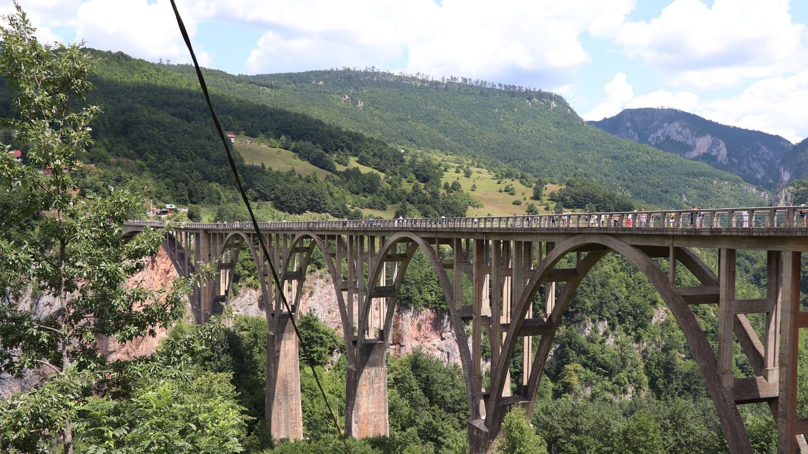
The Đurđevića Tara Bridge was built in 1938–1940 to a design by engineer Mijat Trojanović. Five reinforced-concrete arches crossed the canyon; the main span measured 116 metres. When completed, it was regarded as the largest reinforced-concrete road bridge of its type in Europe [6].
For millennia, the gorge had dictated where a route must stop. Five concrete arches one day carried it farther. There is something beautiful in this side of engineering: it rarely cancels geography. A mountain remains a mountain, the river continues below, and the distance between the banks does not disappear. A new line simply appears in space where none existed before.
In 2019 there were already two zip lines beside the bridge. I chose the shorter one. Before the start there is just enough time to look down and prepare for height, speed, and what seems certain to be a respectable set of strong sensations. Then they let you go, and almost immediately someone receives you on the opposite side.
I barely had time to be frightened. The canyon was formed on a timescale difficult to imagine; I needed only a few seconds to cross it. It turned into an unexpectedly effective geography lesson.
On the other side stands a monument to engineer Lazar Jauković. At that point the bridge abruptly stops being only an engineering structure.
Why blow up an almost new bridge?
Today the bridge is surrounded by tourist buses, cafés, viewpoints and zip lines. It is difficult to imagine that only two years after construction, its fate was being decided for entirely different reasons. To understand why an engineer who had helped build it later had to disable part of the nearly new structure, we need to leave the canyon briefly and enter the history of the Balkans.
Many travellers from outside the region have only a vague idea of what happened here in 1941–1942. Yugoslavia is often remembered either through Tito’s partisans in broad outline or through the wars of the 1990s. Between those images lies one of the most complicated theatres of the Second World War.
On 6 April 1941, Nazi Germany and its allies attacked the Kingdom of Yugoslavia. The country was defeated within weeks and partitioned among Axis powers and dependent regimes. Montenegro fell into the sphere of Mussolini’s Fascist Italy, and Italian forces were in control when a large uprising began there in the summer of 1941. The resistance soon fractured. Josip Broz Tito’s communist Partisans continued armed struggle against the occupiers and linked it to a future socialist Yugoslavia. Another major force, the Chetniks, looked to the monarchy and the pre-war Yugoslav order. The movement was not homogeneous. As the internal conflict deepened, some commanders in Montenegro came to regard the Partisans as their principal enemy and in 1942 concluded agreements with the Italian authorities, receiving supplies and taking part in joint actions against Partisan forces. The familiar picture of “occupiers versus resistance” therefore explains only part of what happened here. The same territory saw resistance to the Axis, an internal armed conflict, and a struggle over the shape of post-war Yugoslavia at the same time [7][8].
The story of the bridge now becomes easier to understand. On 6 May 1942, Partisan forces put the crossing out of action. Lazar Jauković had taken part in its construction and knew the structure well, so only the last small arch, about 44 metres long, was destroyed. Most of the complex bridge survived, but traffic across the canyon became impossible. A wartime archival chronology explicitly links the operation to cutting the Pljevlja–Nikšić communication route [9][6].
Jauković was later captured and executed near the bridge. After the war, the damaged section was rebuilt. The story is often retold more romantically, as though the engineer had destroyed “his own bridge”, although the design belonged to Mijat Trojanović and Jauković was one of the specialists involved in construction [6].
Reality loses nothing by being more precise. The river divided the banks according to the laws of nature. War divided them by human decision.
Piva: when the river itself changes
After Tara, the route returns to water, but the picture slowly changes. Piva appears among the mountains as a long strip of blue-green water. The shores vanish around bends, the surface reflects the slopes, and the first impression is almost inevitable: another beautiful mountain lake in Montenegro.
Only its present shoreline is very recent.
Piva Lake is a reservoir created behind the Mratinje hydroelectric dam. It extends for more than 30 kilometres, covers about 13.2 square kilometres and holds roughly 880 million cubic metres of water. The concrete arch dam is about 220 metres high, while the reservoir level can fluctuate by many tens of metres [10].
On Tara, people carried a structure across an existing landscape. Here they changed the landscape itself.
Along the water, the road alternately clings to the slope and disappears into tunnels. The mountain left no space for a road on the surface, so people took the route through its interior.
Then a Russian-speaking traveller encounters an association that no hydrologist planned. The river’s name sounds suspiciously familiar: Piva.
At first it invites an easy joke. Then the linguistic history turns out to be better than the joke. The Russian word pivo, “beer”, goes back to a Proto-Slavic word connected with the verb piti, “to drink”; originally it had the broader sense of drink or beverage [11]. South Slavic hydronymy also contains a hypothesis linking the river name Piva to the same root piti. Researchers have compared it with Slovenia’s Pivka and with karst hydrology, where water can disappear into rock and later emerge again [12].
So translating Piva simply as “water” would be too bold, while connecting the river directly with a modern glass of beer would be much too literal. Yet deep in the language, the river and the familiar word may indeed meet around one ancient human action: drinking.
After karst, dams and hundreds of millions of cubic metres of water, the detour feels almost like a well-earned rest.
The monastery that had to move away from the water
The new lake carried a cost invisible on a hydrological map. The old Piva Monastery stood inside the future flood zone.
Its Church of the Dormition was built between 1573 and 1586. When the hydroelectric project advanced in the twentieth century, it became clear that the original site would disappear beneath the water. The monastery was preserved by moving it about two kilometres. Work was completed in 1982; around 1,260 square metres of wall paintings were removed and then reinstalled at the new location [13].
Morača and Piva unexpectedly become the two ends of one story. At Morača, the monastery had existed for centuries inside a natural river valley: architecture and religious life adapted to the place. At Piva, the valley itself changed first, and the church had to move with the new geography.
Here an engineering calculation meets a question for which no separate variable exists in the formula: what from the old world do we value enough to preserve? The answer became strikingly material: walls, stones and 1,260 square metres of paintings.
When a quiet landscape changes scale
After bridges, tunnels and a dam, it is easy to feel how far people have moved from an ancient fear of natural forces. We calculate structures, regulate flows, watch glaciers from satellites, track moving slopes and build models that let us test dangerous scenarios in advance. None of this is an illusion: engineering, forecasting and early-warning systems genuinely save lives.
But a mountain valley rarely obeys a single process. Ice is linked to rock, slope to channel, precipitation to water level. Sometimes several well-understood phenomena join into a chain faster than human protection can react. Then the old language of elemental force, supposedly displaced by calculations and instruments, becomes relevant again.
Kolka, 2002
On 20 September 2002, a major rock-and-ice collapse occurred on the northern slope of Mount Dzhimara in North Ossetia. Ice and rock struck the Kolka Glacier, after which a huge mass rushed down the Genaldon valley. Ice and debris filled roughly 18 kilometres of the valley; at least 125 people were killed. For millions of Russians, the Karmadon disaster is inseparable from the name of actor and director Sergei Bodrov Jr. and the film crew of The Messenger [14].
The disaster was followed by a major scientific effort. Geographers Dmitry Petrakov, Sergei Chernomorets and Olga Tutubalina repeatedly returned to Karmadon, compared field observations with satellite imagery and reconstructed the sequence of events. NASA’s long account of their work describes early expeditions carrying GPS receivers, simple surveying equipment and cameras, followed by the use of remote-sensing data that revealed changes across the whole valley [14].
An important transition had taken place: the disaster could no longer be prevented, but its mechanism could be understood in growing detail. Satellites showed what had happened from above; fieldwork allowed researchers to read its traces on the ground.
Twenty-four years later, a similar class of hazard returned to the centre of attention, this time in the Himalayas.
The Himalayas, 2026
On 26 August 2026, a major high-altitude collapse occurred near the Nepal–Tibet border. According to the preliminary reconstruction reported by Reuters, the lower part of a glacier failed and a mass of ice, rock and loose material dropped about 1,200 metres before entering the river system. In some places the water level rose by around nine metres in half an hour, and the resulting flow destroyed settlements, roads, bridges and hydropower infrastructure [15].
The resemblance to Kolka does not mean that the mechanisms were identical. Each disaster is shaped by its own geology, relief, volume of ice and water, and slope conditions. What is familiar is the transition: a local event high in the mountains entrains more material, enters a river valley and becomes a disaster far downstream.
By 4 September, more than 1,250 deaths had been reported and over 4,200 people were missing. Satellite data were being used to identify the source area and monitor the aftermath, while newly formed lakes upstream were treated as possible sources of further flooding [16].
This is where comparison with 2002 becomes especially revealing. In a quarter of a century, people have learned to see events sooner, reconstruct their causes faster, and build warning systems that operate close to real time. The territory of understood risk, where we can measure, model and prepare, has expanded enormously. Beside it remains a territory of uncertainty, especially where several natural processes merge into one rapidly developing chain.
Nature, meanwhile, is not competing with us. We invented the competition ourselves.
When knowledge becomes a choice
If we travel the route once more in memory, an interesting sequence appears. Beside Morača, water enters an ancient religious story while also flowing through a perfectly real mountain valley. Farther on it reveals itself as a geological force, dissolving limestone, transporting material, deepening channels and, together with other processes, creating the relief that travellers now admire.
At Tara, people intervene visibly in the scene. The canyon remains, the river continues below, but a bridge appears over the gorge. Geography presents an obstacle; engineering knowledge draws a new line through it. At Piva the scale changes again: the dam raises the water, alters the river regime and redraws the shoreline. A large reservoir appears, and roads adapt to a landscape that is now partly a human creation.
Then the limits of a purely technical question become visible. A dam can be calculated. The future water level can be calculated too. But calculation alone cannot decide what to do with a sixteenth-century monastery that will lie inside the flood zone. The decision to preserve it, dismantle it, move it and reconstruct it together with its paintings comes from a human judgment about the value of the past.
Knowledge of nature therefore changes the character of our decisions as well. The more we can do, the more often we have to ask not only how to transform a place, but why, at what cost, and what must not be lost. Water remains a physical reality governed by the same laws whether a monk, a geographer or an engineer looks at it. What changes is the range of questions people are able to ask themselves.
Perhaps that is why I increasingly like to look at geography beside history and religion. The material world becomes easier to understand when we know not only what rocks form a mountain or where water goes underground, but also why people chose these places for churches, roads and settlements, what they tried to preserve, and what meanings they placed around a natural landscape.
On another day of the same journey I reached Ostrog. There the relationship is even more immediate: the monastery seems to enter the limestone wall itself, while karst, groundwater, vertical relief and human faith occupy almost the same space. But that is a large new story.
The present one began with quiet water beside Morača and ended with a question that had not occurred to me at the start of the day: how much of the landscape around us belongs to nature, how much has been made by people, and whether a clear boundary between the two can be drawn at all.
That, perhaps, is reason enough to return to old photographs after a few years.